Land Slope Calculator
Convert rise and run or start and end elevations into percent slope, degrees, slope ratio, contour crossings, drainage direction, erosion class, and usable field area.
Pick a starting point for common farm, garden, pasture, and hillside situations. Each preset fills measurement method, slope, contour interval, cover, and plan area.
Slope Result Breakdown
Enter measurements to estimate slope class and field impact.
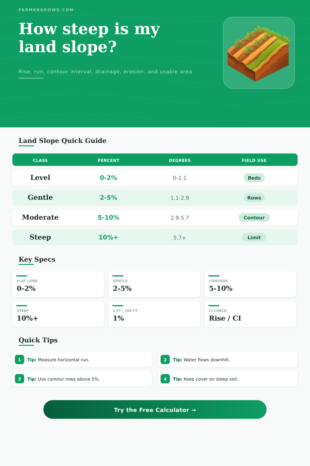
| Percent slope | Angle | Approx ratio | Example rise |
|---|---|---|---|
| 1% | 0.57° | 1:100 | 1 ft over 100 ft |
| 2% | 1.15° | 1:50 | 2 ft over 100 ft |
| 5% | 2.86° | 1:20 | 5 ft over 100 ft |
| 10% | 5.71° | 1:10 | 10 ft over 100 ft |
| 20% | 11.31° | 1:5 | 20 ft over 100 ft |
| Slope range | Typical fit | Management focus | Usable planning |
|---|---|---|---|
| 0-2% | Beds, pads, level blocks | Drainage outlet and ponding | 98-100% workable |
| 2-5% | Row crops, hay, garden rows | Row direction and runoff | 94-98% workable |
| 5-10% | Contour crops, orchards | Cover crop and contour rows | 85-94% workable |
| 10-18% | Pasture, vineyard, terrace blocks | Traffic control and strips | 70-85% workable |
| 18%+ | Bank, woodland, protected cover | Keep soil covered | 45-70% workable |
| Contour interval | Good map use | Lines for 10 ft rise | Field note |
|---|---|---|---|
| 1 ft | Small fields and pads | 10 lines | Fine detail for grading work |
| 2 ft | Garden, orchard, lane checks | 5 lines | Common for practical layout |
| 5 ft | Pasture and broad fields | 2 lines | Useful for general slope planning |
| 10 ft | Rough hillsides | 1 line | Too coarse for small drainage details |
| Cover condition | Best slope range | Risk effect | Planning note |
|---|---|---|---|
| Bare tilled soil | 0-5% | Raises erosion class | Avoid long uninterrupted downhill rows |
| Standing crop or stubble | 0-10% | Moderates runoff impact | Residue slows surface flow |
| Pasture sod | 0-18% | Lowers erosion pressure | Dense roots protect steeper ground |
| Mulch or cover crop | 0-12% | Strong protection | Good for gardens and orchards |
| Terraced or contour managed | 5-18% | Redirects runoff | Depends on outlet maintenance |
Slope is used to measure the tilt of a piece of land. The slope of the land will determine the way in which the water will move across that land, as well as the amount of usable ground that a person will have available for use with that plot of land. The slope will act as a signal for the land as to whether the plot will allow for the water to drain well from that patch of land, whether the land will hold too much water, or if the land will experience soil erosion if rain falls on that patch of land.
Each of the mathematical calculations can be performed with the calculator provided, but its also important to understand the reason for calculating the slope of the land. Farmers and gardeners use the slope of the land to determine the types of crops that can be planted on that land. If the slope of the land is gentle, it may be possible to run the rows of crops straight down the slope.
Why Land Slope Matters for Water and Farming
If the slope of the land is much steeper than these gentle slopes, it may be necessary to use strips to prevent erosion, cover the land with different type of crops (cover crops), or use terraces to allow the land to be better used. These different options is based off the degree of the slope of the land, as well as the type of soil cover that may be growing on that slope. Bare soil will behave differently from soil that is covered with pasture sod or mulch.
The various fields and land features will determine the inputs for the calculator. The rise and the run of the land will contribute to the slope of the land. Additionally, the change in the elevation of the land is one of the ways to calculate the slope of the land.
The horizontal distance of the land is another of the measurements that is required for calculating the slope. The contour interval will allow the land to be visualized in relation to how many contour lines would cross the land, as well as provide information regarding the drainage of the land. Finally, the cover of the land and the way in which that land is used is another of the data elements for the calculation.
Each of these elements will allow the individual to calculate the slope of the land, as well as to understand how that slope may impact the use of that land. Many individuals may focus solely upon the percentage slope that is calculated with this tool. However, focusing only upon this percentage may cause an individual to miss some of the key features of that slope of land.
For instance, a slope that may be classified as moderate is not necessarily one that permits certain types of farming equipment to be used on that plot. Additionally, the moderate slope may force the individuals to plant their crops in a different way than if the land was flat. These tables will provide information regarding the different slopes of land, and how those percentages relate to the use and layout of crops on the land.
For instance, the slope of land that is to be used for a vineyard may have a steeper percentage than the slope of land that is to be used for vegetable plots. The drainage of a plot of land is another element that many individuals may not expect to be part of this particular calculation tool. However, if the end of the slope is lower than the beginning of that slope, the water will move towards the lower point of that land feature.
The direction in which the land drains will impact the location of grassed waterways that are built on that plot, the grading of access lanes to the land, and whether swales should be built away from any wet spots on the land feature. This direction is visualized with the tool to allow individuals to understand the drainage of that slope without having to make estimations regarding that drainage. Some of the mistakes that can be made with calculating the slope of the land are due to individuals measuring the land along the ground itself, instead of measuring the horizontal distance between those two points of measurement of the land.
Additionally, another common mistake is ignoring the type of soil cover that is growing on the land. For instance, a slope that is steep may be covered with good pasture crops that remain stable over many years, but a slope that is steep and bare of any cover will experience soil erosion quickly if rain falls on that land. The usable area of the land is estimated in this field with the calculations performed by the tool.
Though the area is not an exact measurement for the land, this estimation will help to prevent individuals from assuming that all acres of land is the same in relation to how farmable that land is. The value of calculating the slope of the land is in correlating those calculations to the physical features of the land itself. For instance, if water stains are seen on the land, or rills form on the land after rainstorms, or the farm equipment appears to lean in one direction of the land, each of these features indicate whether the calculated slope of the land is accurate.
These different features will allow individuals to use the tool to establish a start to measuring the slope of the land, but then to walk the land itself. Based upon the measurements that were calculated with the tool, individuals will be able to determine if any adjustments must be made to the plan to use the equipment on that plot of land. Actually, people should of checked the ground before they starts.
A modern farmer would of known that the lands size can change if the soil is loose. You’ll find that the slope of land can be tricky when you’re looking at many different types of furnitures or trees. Its important to recieve the right data first.
If you want to be comfortabley able to farm, you should of measured the distance more carefuly.