Acre to Square Meter Converter
Convert acres, hectares, square meters, square feet, and square yards while estimating usable land, slope surface area, plot dimensions, perimeter, and map-scale measurements.
Use direct acreage for deeds and field notes, plot dimensions for measured beds or paddocks, and map scale when you are tracing an aerial print or hand map. Results show gross horizontal area plus slope-adjusted and usable area.
Converted Area
Gross horizontal area, slope-adjusted surface area, net usable area, and a perimeter estimate for boundary planning.
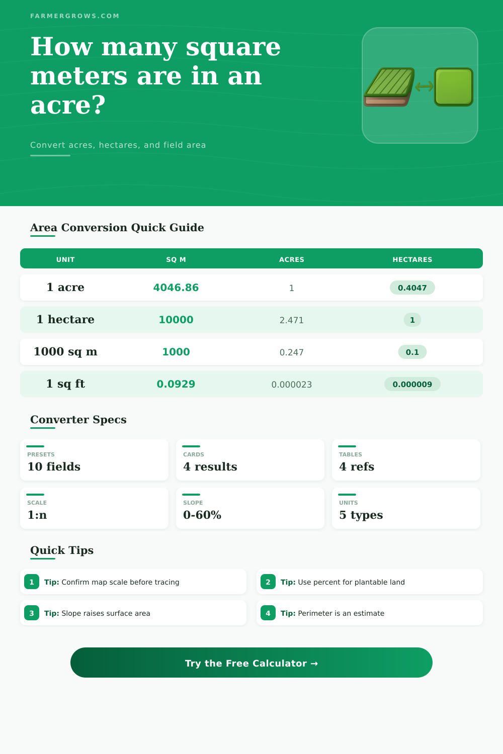
Area Conversion Factors
| From | Square meters | Acres | Hectares |
|---|---|---|---|
| 1 acre | 4,046.8564 sq m | 1 acre | 0.4046856 ha |
| 1 hectare | 10,000 sq m | 2.471054 acres | 1 ha |
| 1 square meter | 1 sq m | 0.000247105 acre | 0.0001 ha |
| 1 square foot | 0.092903 sq m | 0.0000229568 acre | 0.0000092903 ha |
| 1 square yard | 0.836127 sq m | 0.000206612 acre | 0.0000836127 ha |
Acre Fractions to Square Meters
| Acre fraction | Square meters | Square feet | Example use |
|---|---|---|---|
| 1/16 acre | 252.93 sq m | 2,722.5 sq ft | Trial bed cluster |
| 1/10 acre | 404.69 sq m | 4,356 sq ft | Small market block |
| 1/8 acre | 505.86 sq m | 5,445 sq ft | Kitchen garden |
| 1/4 acre | 1,011.71 sq m | 10,890 sq ft | Homestead plot |
| 1/2 acre | 2,023.43 sq m | 21,780 sq ft | Orchard or paddock |
| 1 acre | 4,046.86 sq m | 43,560 sq ft | Full field reference |
Common Plot Dimensions
| Plot dimensions | Square meters | Acres | Estimated perimeter |
|---|---|---|---|
| 50 x 100 ft | 464.52 sq m | 0.1148 acre | 91.44 m |
| 100 x 100 ft | 929.03 sq m | 0.2296 acre | 121.92 m |
| 100 x 200 ft | 1,858.06 sq m | 0.4591 acre | 182.88 m |
| 208.71 x 208.71 ft | 4,046.85 sq m | 1 acre | 254.45 m |
| 50 x 100 m | 5,000 sq m | 1.2355 acres | 300 m |
| 100 x 100 m | 10,000 sq m | 2.4711 acres | 400 m |
Slope and Usable Area Adjustments
| Planning factor | Input example | Effect on 1 acre | When to use |
|---|---|---|---|
| Usable percent | 90 percent | 3,642.17 sq m usable | Remove lanes or wet spots |
| Mild slope | 5 percent grade | 4,051.91 sq m surface | Gentle orchard or pasture |
| Moderate slope | 15 percent grade | 4,092.12 sq m surface | Hillside bed planning |
| Steep slope | 30 percent grade | 4,225.21 sq m surface | Terrace or bank estimates |
| Map scale | 4 x 4 cm at 1:2500 | 10,000 sq m | Aerial print takeoff |
| Perimeter check | 1 acre square | 254.46 m boundary | Fence, hedge, or edge line |
Map scale note: Check whether your map scale is a representative fraction such as 1:2500 or a bar scale. The calculator assumes every drawing unit equals the same number of real units.
Usable area note: Use gross square meters for legal area and net usable square meters for seed, irrigation, stocking, and bed layout. That keeps records and field planning separate.
To determine the size of the land that you intends to farm, there are a variety of method that you can employ. For instance, you can look at the land’s deed, use a tape measure to measure the land directly, use an aerial photograph of the land to determine its size, or read the land plan that was created for that specific plot of land. Each of these method will allow you to determine the size of the land in acres, hectares, or square meters.
Furthermore, the size of the land is another thing that will impact how much seed is order for that land, how the land will be laid out in the garden, and how long the fence for the plot will need to be. In addition to determining the size of the land, it is also helpful for farmers to understand the difference between the gross area of that land and the usable area of that land. For example, if the land is only one acre in size, the land may appear to be that size on a plot plan, but additional features of the plot, such as slopes in the land, will reduce that usable area.
How to Measure Your Farm Land and Find Usable Area
For instance, a five-percent grade in the land will require extra length to each row that is to be planted with crops, and a fifteen-percent grade will reduce the usable area of that land even more than a five-percent grade. A calculator will allow you to input the grade of the land and the percentage of that land that is usable. However, the calculator will not be able to determine if that remaining area is suitable to grow the types of crops that are to be planted.
Another of the measurements of the land that the calculator provides is the direct acreage of the land. This is most useful when the land deed includes a figure for the acreage of the land, but you have to convert that acreage to another measurement for another reason, such as for a permit or for the purchase of seed. Additionally, if a map is to be paced, or if you trace a map, the tool can calculate the acreage of the land using length and width measurements of that map or plot.
A circle is another shape that can be used to calculate the area of the land, although that acreage measurement will ignore any fences or tree lines that might be established on the boundaries of that land. Additionally, map scale entries will allow the land acreage to be determined from a map printout, which may be an old survey printout of the land. In addition to these measurements, the calculator will determine the slope of the land.
The slope measurement is calculated using the principles of geometry regarding the hypotenuse of a right triangle. The base of the right triangle is the horizontal distance of the land, while the height of that right triangle is the vertical distance of the land. The acreage and slope of the land can be calculated together; for instance, a thirty-percent grade in one acre of land will increase the area of that land by approximately one hundred seventy-eight square meters of area.
The increase in area due to slope can be important for any work that is to be performed on that land. However, the slope of that land will not change the legal acreage of the land. Another of the measurements that the calculator provides is the usable percent of the land.
This number is typically first guessed by farmers, and often is a percentage like ninety-two percent. However, after farmers begin to use the land, it becomes apparent that the usable percent of that land is actualy less than what was first guessed. The usable percent can be tested with the calculator, and testing various percentages will allow the farmer to see how a ten-point reduction of the usable percent will impact the total number of square meters that are usable for farming.
Another of the features that is provided to the farmer is a plot size table that displays some of the dimensions of the land plots that are commonly used by farmers. For instance, one hundred by two hundred feet is approximately half of an acre. Additionally, a fifty by one hundred meter plot is slightly more than one acre in size, and is often used for market gardens.
These dimensions are not rules that farmers must follow, but they do provide starting points for the farmers to compare their land plots to those dimensions. Additionally, the tool also allows for the estimation of the perimeter of the plot that is to be farmed. The tool calculates the perimeter of the land assuming that the land is a rectangle.
An aspect ratio can be set for the rectangle, which will impact the measurement of the perimeter. For instance, a long and narrow acre of land will have a different perimeter than a square acre of the same size. However, as with all estimates, the actual perimeter will likely not match that which is calculated by the tool.
Therefore, the tool will be useful in providing a planning number for the length of fencing that is to be purchased for the land. The tool will also calculate the map scale entries for the land. However, these entries have the potential to introduce errors into the calculation of the acreage of the land.
For instance, the printed map that is used to calculate the acreage of the land may use a representative fraction, such as one to twenty-five hundred. However, the paper on which that map is printed may stretch or shrink due to the humidity in the area. Thus, the acreage that the tool calculates is only as accurate as the printed map that is used.
Errors in the map printout can be corrected prior to ordering the seed that will be planted on that land. Another of the calculations of the tool is the distinction between gross area and net area. One hectare is equal to ten thousand square meters of area, regardless of the slope of that land.
Additionally, the hectare measurement will decrease in size by the same percentage as the acre measurement when that percent of the land that is usable is applied to that area measurement. Having both the gross area and net area displayed on the screen will be of help to the farmers when they switch between different suppliers of metric seeds. One of the starting points for most farmers is to use the acreage of the land that is to be farmed.
Additionally, because the slope of the land will not change the legal acreage, that same acreage can be used to calculate the amount of irrigation line or mulch that is to be purchased for that land. The perimeter estimate will be of help to farmers when they are planning their first pass at building fences for the land. Thus, after determining the acreage of the land, the usable percent of that land, and the perimeter of that land, the remaining conversions will be complete.